VENUES
If you join us you have access to river fishing on the Bristol Frome and the Bristol Avon. The majority of our river water fishing however is located on the Bristol Avon. The Bristol Avon flows from its twin sources near Sherston and Tetbury to its confluence with the River Severn at Avonmouth and travels a total of 117 kilometres (72 miles). We control many miles of fishing on the Avon from the highest coarse fishing spot at Daniels Well and at various points in between to the lowest club controlled fishing at Jack Whites, Keynsham. Details of which you will find on our River Venues link.
We also have excellent stillwater fishing at Pawlett Ponds, Highbridge, Somerset; Sabre Lake, Calne, Wiltshire; Shackells Lake, Hamswell, Bath and our prize fishery Tockenham Reservoir, Lynham, Wiltshire. View full details below.
| Lake | Location | Nearest Sat Nav Post Code |
|---|---|---|
|
Tockenham Reservoir |
Lynham, Wilts (C) |
SN15 4DS |
|
Pawlett Ponds |
Highbridge, Bridgwater (C) |
TA6 4SE |
|
Shackells Lake |
Lower Hamswell (C) |
BA1 9DE |
|
Sabre Lake |
Calne (C) |
SN11 8QH |
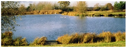
TOCKENHAM RESERVOIR
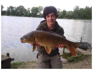
Tockenham Reservoir near Lyneham lies just three miles from M4 intersection 16 via the A3102. This beautiful 12.5 acre lake, surrounded by oak woodland, was created in 1810 to provide water for the Wilts and Berks Canal. It was purchased by us in 1980 when we were Bristol, Bath and Wiltshire Amalgamated Anglers. It has since been developed into a magnificent fishery stocked with carp to 30lb, tench to 7lb, bream to 8lb, plus roach, perch and crucian carp. All fishing is from platforms, including three purpose built for the wheelchair disabled, and there are good parking facilities.
Open all year
NO DAY PERMITS – Full Membership only
Ample parking access – head clearance 6′ 6”. Supreme lake. 12.5 acres and over 90 swims.
Excellent head of high quality carp, bream, tench and most silver fish.
Directions: Follow the B4069 from Chippenham to the A3102 through Lyneham passing the airfield on the right. Look for the White Hart pub then take the first left (Bowds Lane) which is 1/2 mile further along towards Swindon. The entrance is on the right 400 yards along this lane. Enter car park and park end on to the trees.
Drivers of tall vans need to remember that the entrance gantry has a maximum clearance of 6 feet 6 inches
Special rules apply at this venue:-
- full membership only – no day permits
- all juniors must be accompanied by an adult
- night fishing by special permit only (apply to secretary)
@ Tockenham Lake (Amalgamated Fisheries Ltd)
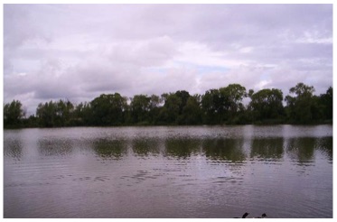
PAWLETT PONDS – Pawlett, Nr Bridgwater
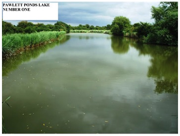

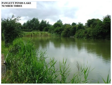
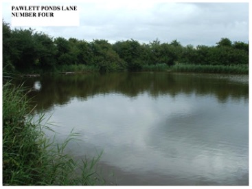
Carp, tench, roach, rudd and other silver fish.
Directions:
From Highbridge take the A38 south towards Bridgwater for 4 miles and turn right into Pawlett Village. Follow Manor Road to the next junction, turn right, then immediately left to the next crossroads.
Proceed over the crossroads into River Road and follow this to the end where a gate crosses the lane. Go through the gate and follow the track on the left to the lakeside car park.Rules:
- no parking on the lakeside, use car park only
- open all year, 5 am to official lighting up time only
- night fishing by Night Permit holders only
- juniors must be accompanied by an adult
Open All Year
Day Permits available at Thyers of Highbridge.
SABRE LAKE – Quemerfield, Calne, Wilts
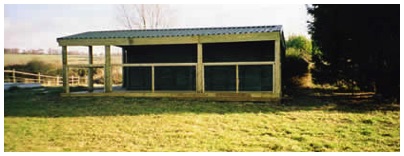
Sabre Lake can be found alonside the A4 approx. 1 mile from Calne, Wilts.
- – It has 30 – 35 swims many with 23 comfortable platforms
- – Onsite shelter with toilet
- – Match bookings accepted
- – Depth varies from 6 ft to 17 ft.
- – Large car park
- – Open all year
Day permits available from T K Tackle, London Road, Calne
Contests booked through Pat Leonard on 01179603378.
The Avon League record was broken here with a catch of 104lb by Stuart White of Premier Angling Black. It was backed up with weights of 77lb, 47lb and 32lb.
@ Sabre Lake Calne (Amalgamated Fisheries Ltd)
SHACKELLS LAKE – Lower Hamswell, Nr Bath

Shackells Lake has a good head of bream, tench and huge carp, plus a good stock of silver fish.There is approximately 300m walk across field from car park.
- Species: carp, bream, roach, rudd and tench
- Depths vary from 7 feet to 15 feet at dam end
- Directions: From the A420 Bristol to Chippenham Road turn right at Wick passing Tracey Park Golf Course. Then bear left to Lower Hamswell crossing over the next crossroad. Follow this lane down to the hamlet of Lower Hamswell and the car park will be found on the left after passing over two cattle grids. Follow the signs from the car park across two fields to the lake
- Special rules and permits apply to this venue
Close Season from 1st May to 15th June
- Fishing times restricted:-
- 15th June – 30th Sept 7am til 9pm
- 1st Oct – 30th April 8am til lighting up time
- Match bookings accepted
River Avon
- Malmesbury.. Daniel’s Well Farm (C) & (T)
- Lower Christian Malford
- Lacock Abbey Fields
- Lacock Mead Farm
- Bathford Candy’s Waters
- Bathampton Weir (Beefeater Bank)
- Bathampton Manor Waters
- Windsor Bridge, Bath
- Grosvenor, Bath
- Swineford
- The Crane
- Jack Whites
Bristol Frome (C)
- Stapleton

Several of the Association’s waters are near overhead power lines carrying up to 132,000 volts. These lines are within reach of rods and poles. Members must maintain a safe fishing distance and must NOT carry assembled rods or poles under these power lines. Always look up.
RIVER AVON
Malmesbury, a picturesque old Cotswold market town with its 12th century Abbey as its’ focal point, is the uppermost point on the Avon open to the coarse angler. Although fishing is difficult when the water is clear it has produced roach and perch of over 3lb and carp of 20lb plus in the past two seasons. The water at Malmesbury is one of the few places where it is possible to catch that elusive 2lb plus roach from shoals of similar size fish.
From Malmesbury the river meanders its way downstream through Sutton Benger then Christian Malford to the market town of Chippenham. This stretch has many weirs barbel, chub and roach predominate in the faster water with large bream shoals in the deeper runs. Individual records include a monster pike of over 33lb and the almost unbelievable tench of 12lb 7oz caught by Rick Seal from Cardiff in the river at Christian Malford in November 1998.
Further downstream at Lacock, the river passes by this National Trust village, best known for its Abbey and as the home of early photographer Fox-Talbot, and onto Melksham. Match weights often exceed 30lb on the upper reaches to perhaps 60lb on the lower reaches near Melksham (if the bream are feeding!). Large barbel are easy to locate and catch on this stretch of river.
The river continues to Staverton, then Bradford on Avon with its old church, Tythe Barn, and antique shops (a great tourist spot). Then on to weir at Avoncliffe and Limpley Stoke (with Freshford on the opposite bank) which provides a magnificent variety of fishing for chub, roach, dace, barbel and bream. The Limpley Stoke weir is a favoured haunt for night fishing for barbel. For much of its course after leaving Wiltshire, the Avon marks the traditional boundary between Somerset and Gloucestershire. The river drops down through Warleigh in a steep valley, here the water runs fast through pools and weed beds and shelters huge barbel. One recorded at 15½lb weight, is very close to the national rod caught record. Roach, dace, chub, tench, perch and bream flourish in this stretch.
There are some sections of the river in Malmesbury, Bath, Saltford, Keynsham and Bristol that are considered “free fishing”.
Please be advised we only control fishing in the venues listed below.
DANIEL’S WELL
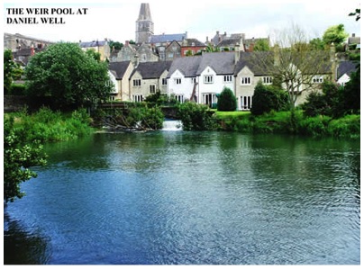
Directions: Access is from two points.
From the A429 Malmesbury “By Pass” approaching from Chippenham turn towards the town centre and then immediately left into Burton Hill where parking can be found. Access to the waters is via the swing gate located to the left of the bridge. Alternative access can be obtained by continuing over the river bridge, along the High Street and turning left at the “T” junction opposite the Market Cross. Follow this road past the Abbey ruins to the next “T” junction turning towards Sherston. Approximately 450m along this road turn left for Foxley, cross over the river around a sharp bend and a parking area will be found on the left outside a large barn.
DO NOT PARK IN FRONT OF THE DOORWAYS TO THE BARN OR ON THE TRACK TO THE FARM JUST BEFORE THE BEND
Access to the water is via the style located just before the bridge. Fishing Rights extend from the bridge downstream for four fields to the town bridge, approximately one and half miles.
CAUTION !!! OVERHEAD HIGH VOLTAGE CABLES ARE PRESENT IN THREE DIFFERENT PLACES ON THIS WATER.
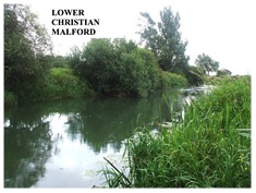
LOWER CHRISTIAN MALFORD
Directions:
Approach from Chippenham on the B4069. Just prior to the river bridge at Christian Malford is a gate and large car park on the right hand side. The waters extend from the car park downstream for approximately one and half miles; (one medium size field and one very large field).
PLEASE NOTE THE WEIR POOL ABOVE THE BRIDGE IS PRIVATE AND NOT OUR WATERS.
BEWARE THERE ARE OVERHEAD POWER CABLES ON THIS STRETCH OF WATER.
LACOCK ABBEY FIELDS
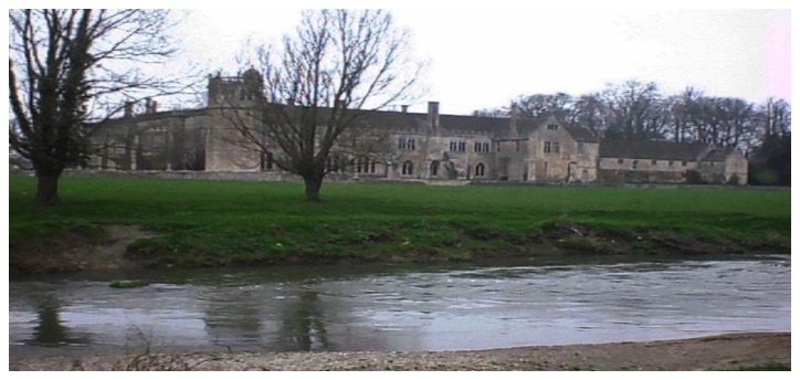
Directions: nearest Sat Nav postcode SN15 2LG
From the A350 Lacock by-pass between Chippenham and Melksham enter Lacock Village and follow the signs for the public car park at the rear of the Red Lion Public House in the High Street.
From this car park go right past the main entrance to Lacock Abbey and approximately 50m pass the entrance to the car park, there is a large wooden farm gate with a sign stating “No Entry to Lacock Abbey”. Pass through this gate and down to the waters.
Please note that the main tourist car park on the Bowden Hill Road is now locked at night and does not open until approximately 10.00am in the morning.
Fishing rights extend from Lacock Bridge up stream left hand bank for three fields.
PARKING IN THE PUBLIC CAR PARK ONLY.
Parking on the roadside verge either side of Lacock Bridge is expressly forbidden.
BEWARE OF OVERHEAD ELECTRIC POWER CABLES
Night fishing by special permit only.
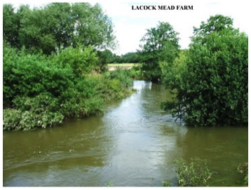
LACOCK MEAD FARM
Directions:
From the A350 Lacock bypass between Chippenham and Melksham enter Lacock village and follow the signs for the public car park. On leaving the car park turn right and follow the road to Lacock bridge. Fishing rights extend downstream of the bridge on the right hand bank for one very large field followed by two smaller ones for approximately one and half miles. Mead Farm is located on the left hand bank downstream and consists of six fields approximately one and half miles to the start of Queenfield Farm Fishery. There is no other suitable parking other than the public car park at Lacock village.
Night fishing by special permit only.
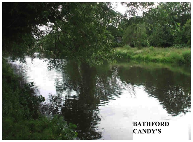
BATHFORD – CANDY’S
Directions:
From Bath take the A4 towards Chippenham. On reaching the large roundabout for the Batheaston by-pass take the OLD A4 towards Batheaston village. Turn right just past the Wagon & Horses Public House down the Toll Bridge Road. Cross the bridge (50p toll payable) and park on the far side on the bridge on the left opposite the entrance to Bathampton Mill (Beefeater Restaurant). If this area is full it is permissible to park just inside the Mill car park. The waters extend for two fields upstream from the Toll Bridge for approximately one and half miles to within one field of Bathford Railway Bridge.
BATHAMPTON WEIR POOL & BATHAMPTON MANOR WATERS
Directions:
From the old A4 in Batheaston turn right down the Toll Bridge Road cross the bridge (50p toll payable) and turn into the Bathampton Mill car park. The fishing rights extend from the weir downstream to the boundary of Meadow Farm.
Park ONLY just inside the entrance NOT down by the restaurant.
WINDSOR BRIDGE, BATH
Directions:
This is a short section of river on the left hand bank downstream of the Windsor Bridge behind the trading estate as far as the old railway bridge.
Parking is in the public area outside of the trading estate and not within the estate itself.
GROSVENOR, BATH
Directions:
Turn down Grosvenor Bridge Road off the A4 as you leave Bath and park on the road near to Grosvenor Foot Bridge. The waters run from the bridge downstream on the right hand bank for approximately three quarters of a mile just behind the Safeway Supermarket, plus one field downstream on the left hand bank from the bridge for approximately 500m.
SWINEFORD & THE CRANE
Directions:
These waters are divided into four sections commencing at the entrance of Pipley Brook Swineford and continuing right hand bank downstream to Keynsham Marina. NO FISHING IN THE MARINA ITSELF. The waters continue from the lock canal behind the marina left hand bank downstream to Jack Whites Cottage a distance of approximately three miles.
Access is from either end of the waters. The upstream access point is from the gate and stile opposite the Swan Inn Swineford on the A431 Bristol to Bath Road, approximately half mile past Bitton Village. Parking is in the lay-by opposite the Swan Inn. Access to the lower end is made from the track which is situated between Matthews Buildings and the scrap yard. BUT ON FOOT ONLY. EXPRESSLY FORBIDDEN TO DRIVE ANY VEHICLE ALONG THIS TRACK.
There is a car park opposite the marina. The waters commence at the junction of the lock canal behind the marina and continues to Pipley Brook Swineford as mentioned above. The second section commences at the end of the lock canal where it meets with the River Avon and continues downstream right hand bank to the small bridge which goes over Warmley Brook close to Jack Whites Cottage.
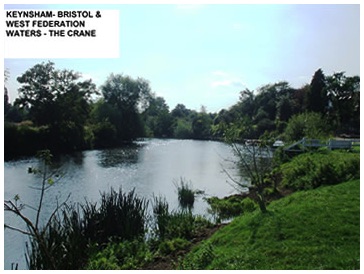
Access is available to the middle of this stretch of water. From Keynsham marina proceed towards Willsbridge A4175 for approximately half a mile park next to Londonderry Farm (Keep entrances clear) this is limited parking, walk down to the river at Jack Whites Cottage, approximately quarter of a mile.
These waters are fished by arrangement with the Bristol & West of England Federation of Anglers.
BEWARE OF ELECTRIC POWER CABLES.
THE BRISTOL FROME
The River Frome is a river in South Gloucestershire. The historic spelling was Froom and this is how the name of the river is still pronounced (as in broom).
Twenty miles long, the River Frome rises in Dodington Park in the Cotswolds of Gloucestershire, then follows a roughly south-westerly route towards Bristol. It disappears underground in a culvert at Eastville and reappears in the city centre where the river ends at its confluence with the River Avon, here its last reach forms part of the Floating Harbour. It has two main tributaries (Bradley and Folly Brooks) and a number of smaller ones.
Between Stapleton and Frenchay the river drops nearly 50 ft, and as a result there were a number of corn and other mills. They were undershot mills with no mill ponds – today, all that is left is a wheel at Snuff Mills. From Frenchay Bridge to Snuff Mills the river is navigable, but only by canoe.
THE BRISTOL FROME, STAPLETON
Directions:
Turn off the B4058 Frenchay Park Road into Brow Hill and cross over the river bridge into Blackberry Hill.
Road side parking can be found just over the bridge.
The waters extend from the bridge down stream on the left bank to Wickham Hill Bridge and then on both banks to the weir.
.